
Glacier Ridge
Recently I got back from an annual backpacking trip that I go on every year with some buddies of mine. This year we headed over to Sequoia and Kings Canyon National Park (SEKI) with our main destination being Glacier Ridge. Last year we followed Phil Arnot’s advice and had an awesome trip to Brewer Basin so we decided to give another one of his routes a go.
Whenever I plan a route my number one goal is always remoteness and Glacier Ridge is almost as remote as you can get in the Sierra’s. I only found one trip report online about the area. The reason it’s so remote is because of how steep the routes are up to the ridge. Glacier Ridge is located between two glacial canyons, Deadman Canyon and Cloud Canyon. Both these canyons have very steep, dramatic walls. I had been up Deadman Canyon once before so I was hoping to take the route up from Cloud Canyon but both trip reports I read said that that way is much steeper so with safety in mind I decided to plan for the route up Deadman.
Day 0:
The plan for this day was to leave for the Grant Grove campgrounds after work for a night of car camping before the trip. Mat had been camping by himself for a couple nights before so the plan was to meet up at his campsite that night. We got a little bit of a late start so we didn’t get in till about 11pm. We setup our tents, had a beer, and all headed off to bed with anticipation of what adventures may lie ahead in the upcoming days. As usual I wasn’t able to fall asleep this first night. I don’t know what it is about the night before a backpacking trip but I’ve never been able to sleep. Last year I was able to score some Lunesta for the trip but this year I was all out of luck. So I spent the entire night tossing and turning without getting a lick of sleep. Not a good start to the trip, especially with a 14 mile first day coming shortly.
Day 1 – Marvin Pass -> Sugarloaf Trail -> Roaring River:
We all got up, ate breakfast, packed up, and headed to the ranger station to pick up our permit. While at the ranger station we were informed that an unusual cold front was coming through in a couple days. This was suppose to bring snow down to 10,000 feet. This had me a little worried because we’ll be up on Glacier Ridge at around 10,000 feet the days that the cold front was scheduled to come in. On top of that in my never ending quest to cut weight I had left my rain gear behind and replaced it with the Gatewood Cape, a rain gear slash shelter combination. This would mean I would be spending a really boring day inside my shelter if any rain came through. While we were at the Ranger Station we told them that our intended destination was Glacier Ridge with which they had absolutely no idea of. This was a testament to how remote this trip was going to be. So we got our permit and headed over to Marvin Pass to start our hike.
After about a 45 minute drive we arrived at Marvin Pass only to be amazed to not find any bear boxes whatsoever. The sign there said to store all coolers and food in our cars which didn’t seem safe and did not sit well with us. We had shampoo, soap, a little bit of food, and the most important items of all, our celebratory beers for when we get back that we needed to store. We decided to bear hang everything minus the beer which we left in our coolers and covered up in our cars. It amazes me that they’re able to put bear boxes deep within the back country but not at this trailhead. I’m not sure if maybe we were suppose to leave our supplies somewhere before we got to the trail head or not.
So finally we were able to start off our hike. The first couple miles up to Marvin Pass were like a punch in the gut. I think it must have been the shock of hiking with a 37 pound pack along with the altitude but it did not feel like I had my legs. It crossed my mind more than once that maybe I hadn’t trained enough and was in for a really long and painful trip. But after a couple hours of huffing and puffing I was able to get my legs back and all was well again. The hike along the Sugarloaf trail was uneventful except for a baby rattlesnake that we saw on the side of the trail. The Sugarloaf trail is by far my least favorite trail in the park. Not because it’s hard, it’s actually pretty flat, but because horses have completely ruined it. It’s a major horse trail so there’s horse crap all over the place. The entire trail is dusty and sandy from all the horses that have trampled it throughout the years. It’s not very fun slogging through the sand with a full pack on trying to avoid the endless mounds of horse crap along the way. Needless to say I was happy to get into Roaring River and be done with the Sugarloaf trail until the return journey back.
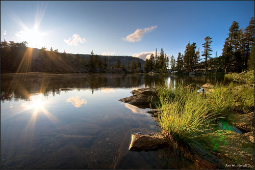
When we got into Roaring River we were greeted by a nice couple from Palo Alto who seemed amazed that we had only been out one day and were heading off trail up to Glacier Ridge. We also talked to the ranger that was posted at the cabin there and she informed us that the forecast now called for the cold front to stay around for an extra day so to expect snow down to 10,000 feet on both Thursday and Friday. This had me a little worried because the last thing we needed was for rain or snow to come down on us on our hike down from the ridge Saturday.
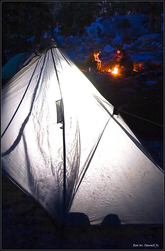
We found a nice campsite with our own personal bear box next to roaring river, setup camp, washed all the dirt from the Sugarloaf trail off our tired bodies, ate dinner, had a small fire, and headed off to bed. To our amazement we didn’t see a single mosquito. From this point on I would never put on another drop of DEET. It was amazing.
Day 2 – Roaring River -> Deadman Canyon -> Glacier Ridge:
I had a little trouble falling asleep again this past night but I had one trick up my sleeve. I had one Valium pill left over from a couple years back that I desperately took with me after not being able to score some Lunesta for the trip. I decided to use it this night in anticipation for the upcoming hike up the ridge.
We got up and did our normal routine. Get up -> eat breakfast -> drink coffee -> dig a hole in the woods -> pack up -> head out. We passed by the ranger cabin again and she again informed us of another update in the forecast. Now it called for snow to come down to 8,000 feet. This meant there would be no way of getting out of it now. I was just hoping that the storm would pass before we had to hike back down the ridge. We all agreed if it rained or snowed on Saturday we were going to have to spend an extra day up on the ridge until it died down, potentially worrying all our loved ones back home.
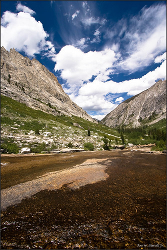
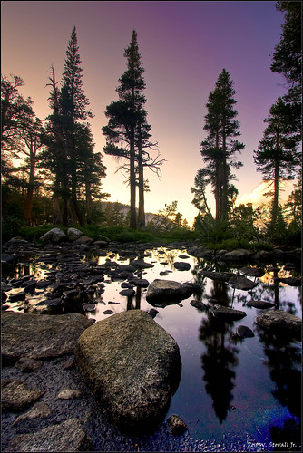
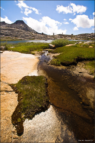
The hike up Deadman Canyon was as beautiful as I remembered it save for the couple horse parties we came across. We made our way up to where the river cascades over smooth granite. This is where the off trail route up to Glacier Ridge starts. From here we followed a dried up seasonal creek up the canyon wall. The route up was VERY steep. We all openly wondered how we were ever going to get down on Saturday. But we pushed on. We made our way on the right side of the creek up big granite slabs. We were trying to follow the guide we had from Arnot and cross over the creek at a certain altitude but as we made our way up we got stuck. Mat and I chose a wrong route (my fault) and ended up hanging on the side of a cliff. A sharp fear rushed through my body when I realized that I couldn’t go any higher and that I couldn’t get down easily. I took a deep breath, got low to the ground, and slid back to safety. After that experience we all decided to head back down a bit and cross the creek at a spot we had spotted earlier. We crossed the creek and headed up the very steep hillside. Eventually after a lot of bushwhacking we arrived at the first lake in the western basin of the ridge. We all gave each other double high fives for having made it up to a place few people have ever been.
We scouted around the first lake trying to find a suitable campsite but couldn’t find any that we liked. We eventually found a really nice spacious site up by the second lake. The site was perfect. Completely flat, close to water, and the only campfire ring in the surrounding area. We would call this spot home for the next three nights. In celebration of making it up the ridge both Mat and I cracked open our flasks of whiskey for a couple swigs while we lounged by the lake preparing our freeze dried dinners. The scene was great but we all couldn’t help but think what was in store for us the coming days as the storm came through.
The wind was fierce this night. We all guy lined our tents in anticipation of the coming storm but that still didn’t stop our tents from flapping around uncontrollably by the gusts of wind that came ripping through our campsite. Surprisingly I didn’t have any trouble sleeping this night though, wind and all.
Day 3 – Layover Day:
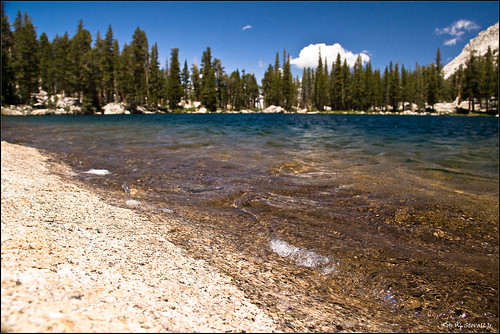
We woke up to an absolutely freezing morning. We all put on all our warmest clothes and hung out by the lake waiting to see if the snow would fall. We debated between going on a day hike or staying by our lake and exploring the surrounding area. We decided on the later, basically a super lazy day by a beautiful secluded lake. We spent the day hanging out and wandering around some by ourselves. Mat and I decided this would be a perfect time to drink our whiskey and so we did. We drank about a half flask each before deciding that the water looked awfully nice for a swim. We headed around the lake to a nice jumping off point I had spotted earlier. From here a big piece of granite comes down from the wall and straight into the water providing a nice little ramp and refuge from the dirt at the bottom of the lake. This lake was by far the best lake I have ever swam in. It was shallow so the lake was surprisingly very warm. Usually at these back country lakes at altitude I take a quick jump in, scream like a little girl, dunk my head in, scream a little more, and run out to dry off. Not this time. The screaming part was still there but after the initial shock of jumping in the water wore out it turned into a very nice and pleasant swim. I stayed in the water for a good 15 minutes and headed out to dry off on the big granite slab. Life couldn’t get any better than this I thought.
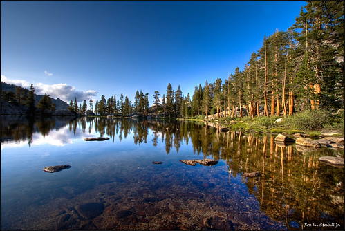
After the swim we hung around some more, ate dinner, then all headed off to take pictures of the sunset. The first lake was especially beautiful during this time. The lake overlooks Deadman Canyon so there’s an illusion of a steep drop off at the end of the lake. I had seen one picture of this lake before our trip and knew this was where I wanted to take my serious pictures.
When we all reconvened we started a small fire, stared at it for a bit, then headed off the bed. Despite seeing a lot of clouds in the distance we never experienced any rain or snow this day.
We did experience the bitter cold this night though. It was absolutely freezing. I’m a pretty warm sleeper and usually sleep with my sleeping bag unzipped but this night I had to completely zip up as well as cinch down the top to where only my nose stuck out. In yet another effort to cut weight I use a short sleeping pad where my legs dangle off the end. Usually I just throw all my clothes down there as insulation and that’s enough to keep me warm but that wasn’t the case this night. I was forced to bring my empty backpack in with me to use as added insulation for my legs. That did the trick but not shortly after I solved that problem I encountered another when I found a puddle of water inside my tent. I quickly realized that I didn’t close my water bladder spout all the way and about a half liter of water leaked inside my tent. Luckily I caught it and wiped it clean with my pack towel before it was able to get itself onto my down sleeping bag. Despite all this I again slept pretty well this night.
Day 4 – Dayhike to Peak 12,240:
We all woke up complaining about the cold we had just experience. Mat informed me that ice had formed in my water filter to which I wasn’t the least bit surprised. I’m sure it would have snowed that night had it rained.
We decided that we needed to go on a day hike today. Our goal was to either head for the pass that connected the western basin from the eastern basin of Glacier Ridge or head up to Peak 12,240 which Arnot cites as one of the most spectacular views he’s ever witnessed from anywhere in the Sierra’s. We decided to head for the peak. The hike up out of our lake was steep but not bad. Along the way we encountered a huge Foxtail Pine that must have been over a thousand years old. It was a sight to see. We made our way up to a lake above ours which was absolutely gorgeous. We were just above the treeline here so the view was very expansive and dramatic. The essence of the high country. We made our way up to the base of a chute that went up to the ridge where the peak stood. We relaxed for a few minutes yelling out in the distance to hear our voices echo back and forth between the steep surrounding peaks. We then headed for the peak but all eventually and unintentionally took separate routes up. The way up got steeper and steeper as we went along and the rocks were very loose. Andrew was the first to make it up but Mat turned back about 3/4 of the way up. I lost sight of Henry on the other side of the mountain and realized I was all by myself about 12,000 feet high. I yelled out for Andrew but heard nothing. I yelled out for Henry and Mat and heard nothing still. That’s when I decided about 100 feet from the top of the ridge to head back down. I really wish I’d have pushed on for the last 100 feet because as it turns out Andrew was up there, he had just gone on over to the peak which wasn’t where we were expecting it to be. I was yelling out at the wrong peak when I was calling his name. After I headed down Henry and Andrew followed suit thinking something had gone wrong. When we all met up Andrew told us it was indeed the most spectacular view he had ever seen and that he was still even trembling from how beautiful it was. “God Damnit!” I thought to myself, a little embarrassed that I had chickened out so close to the top.
We all headed down and passed by the beautiful lake once more, this time stopping for a few minutes to take in the surrounding area. When we got back down to our lake we quickly ate a late lunch and lounged around yet again. Mat and I decided it was happy hour yet again and finished the rest of our flasks of whiskey. Henry joined in the fun with his small bottle as well. We ate dinner, had a small fire, then headed off to sleep for what would be our final night in the wilderness.
Day 5 – Deathmarch to the cars:
We all woke up with the thought of ice cold beer and freshly baked pizza in our minds ready to head back home. The original plan was to hike out to the Sugarloaf, spend a night there and then hike out to the cars, beer, showers, pizza, and eventually home.
We packed up and everyone save Mat skipped breakfast and fueled up with cliff bars and trailmix instead. We all made sure everything was packed securely in anticipation of the steep hike down. I usually hike with my camera strapped to my shoulder straps but decided to instead pack it away to more easily see my feet. We started the hike down and about a couple hundred feet down the slope I slipped on a rock and landed hard on my bottom. Not a good start I thought to myself. We made our way trying to retrace our steps as best we could and zig zagged down the steep dirt hillside. We eventually got to a point where the hillside got extremely steep and realized we had gone too far from where we had crossed the creek before. We hiked back up then over the creek. The rest of the hike down was pretty easy over the granite slabs and the route obvious. We all made it down safely and again the double high fives made an appearance. The hike down was actually a lot easier than the hike up I thought, probably because we knew which way to go.

From this point on we booked it down the trail to Roaring River where we choked down a lunch we were all sick to death of. We all asked how everyone was feeling with the secret thought that maybe we would be able to make it out to the cars today. We again blazed it on the Sugarloaf trail to where we crossed the river about a mile from the Sugarloaf where we refilled water and universally decided that we were going to go for the cars tonight, headlamps and all. Stoked to get to beer, showers, and hot food we filled our water bladders to the brim and started our death march out of the back country. We had done this exact same thing the year prior, combining two days into one, and joked about how it doesn’t matter how far in we are, we’re hiking completely out in one day.
By the time we got to the Sugarloaf the excitement had worn off and the thought started to sink in that this was going to really hurt. I could feel myself getting worn out already and there was still a good 8-9 miles to go. By the time we got to Comanche Meadow I had already bonked. I ate the rest of my dried fruit and trail mix hoping that that would give me the necessary energy to get over the pass, and the hardest part of the hike that day. From this point on I was running completely on fumes. Every time we headed uphill I wanted to fall over but eventually after much pain we finally made it to the top. The sun was going down when we made it to the junction to the last 2 miles to the cars. At this point I felt like I was going to throw up and was preparing myself to puke while I walked because there was no way I was going to stop this close to the cars. We finally made it to the cars after a 20 mile day. No double high fives were given here because we were all so exhausted. We didn’t even crack open our beers (a backpacking first!) because of how tired we were. We gathered our stuff, which survived the bears, and headed out to Grant Grove to take our much needed showers. After our showers we drove down and met up at Denny’s (only place that was open) where we overindulged on hot food and grease and reminisced about yet another awesome backpacking trip.
More pictures from this trip can be found here.